Camp Iron Mountain, California
|
In early 1942, the 23rd Armored Engineer battalion
constructed Camp Iron Mountain with over 40 miles of gravel roads,
firing ranges, walkways, and thousands of 6-man pyramidal tents. In
addition, the camp had 15 shower buildings, 26 latrine buildings, an
amphitheatre, four elevated water tanks and over 9,300 feet of water
pipes with two centrifugal pumps and a chlorinator to supply the camp
with fresh water from the Metropolitan Aqueduct. The camp was laid out in
a design typical of all DTC camps- a rectangular shape roughly 2-3 miles
wide and a mile deep, and rocks were used to line roads, walkways, tent
areas, native plants, mess areas, etc... Camp Iron Mountain is
unique in that is has two altars built of a stone- an Episcopalian and
Catholic one, each on either side of the camp. Additionally, there are
the remnants of a contour relief map in a 200 x 175 foot area that was built by
the Army Corps of Engineers. The map covered the area from Phoenix to
Indio, and from Needles to Yuma, and was complete with small wooden
signs indicating topographoc features, railroads, roads, mountains,
cities and other DTC camps. The wood footbridge walkway over the map is
no longer there and the small wood signs to identify the mountain ranges
are faded.
Iron Mountain is likely the best-preserved camp, as
prior to the establishment of California Highway 62 the area was
extremely isolated. However, this isolation protected the camp
from vandalism. Today, rock-lined walkways and roads as well as
unit insignia are still clearly visible at Camp Iron Mountain. |
 |
|
| From the photo album of a 3rd Armored Division soldier from 1942- 'our desert camp.' Copyrighted Photo | Same area today. |
 |
|
| Men from the 191st Field Artillery Brigade and their Model 1918 155mm howitzers, August 1942. Copyrighted Photo | Rock-lined roadway. |
 |
|
| A Caterpillar tractor used to tow the heavy 155 mm howitzers. Copyrighted Photo | Same area- the distant mountain on the right lines up. |
 |
|
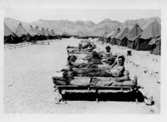
| Soldiers of the 80th Infantry Division sunning themselves after maneuvers. The 80th was stationed at Camp Laguna in Yuma, but spent some time at Iron Mountain for extended desert maneuvers. | Same area. |
|
|
|
| An old camp road. | Looking south-southwest towards the Granite Mountains. Camp Granite was at the base of those mountains 4 miles away. |
|
|
|
| The contour relief map area. The mounds of dirt were mountain ranges within the DTC area. | Relief map area. |
|
|
|
| Creosote can generally live between 100-200 years, which explains why many of them have circular rings of stones around them. Clearly the men who built the camp wished to embrace some desert landscaping. | |
|
|
|
| This may have been a unit HQ area, or flagpole location. | Rocks mark the area where a tent was located. |
|
|
|
| Rock walkway and tent area. | Walkway and tent area. |
|
|
|
| Unit insignia. | The Catholic altar with a rock-lined sanctuary area. |
 |
|
| A 1943 circa photo. Smoke trees were on either side of the altar. | In 2014. |
 |
|
| 1943 circa photo with a military chaplain at the altar. | Same angle today. |
|
|
|
| Standing behind the altar looking at the spectacular view ahead. | A monument at the camp on Highway 62. |